Regional ecological footprint
Why we monitor our regional ecological footprint
Waikato Regional Council needs to know about our region’s consumption of natural resources, how much waste is produced, and how that waste is dealt with so we can measure the effect of these activities on our region.
Our regional ecological footprint tells us how our lifestyle impacts on the environment. It will also help us understand how Waikato people’s current actions affect our region’s future economy and our quality of life.
An ‘ecological footprint’ is a measure of the amount of productive land required to support the lifestyle of an individual, a city, region or country in today’s economy. It is calculated as the total of the different land use types (built up areas, grazing and crop land, managed forest land, energy land and fishing grounds) required for production and consumption of goods and services (food, housing, transport, consumer goods and services). Our regional footprint includes:
- land used in other regions and countries to provide imported goods consumed in this region
- 'direct' land occupied by a sector or activity in this region, for example ‘direct’ land might be land used directly for farming
- ‘indirect’ land used to produce the goods and services supporting any of this region’s sectors or activities, for example land used for processing farm products such as for dairy factories or meatworks
- ‘energy’ land that is used to absorb carbon dioxide released into the air from the burning of fossil fuels.
Ecological footprints are usually expressed in hectares, or hectares per capita (per person), for a given year. The larger the ecological footprint, the more resources needed to sustain an individual's or population’s current lifestyle.
This indicator monitors:
- The area of productive land required to produce the resources we consume and to deal with the waste we produce in the Waikato region.
- The composition of this region’s ecological footprint in terms of ‘direct’ land and ‘indirect’ land.
- The degree of ‘embodied’ land included in this region’s ecological footprint (for example, land overseas used for the production of goods imported into New Zealand for consumption in the Waikato).
Results - data and trends
It is calculated that 0.85 million hectares of land are required to support the Waikato region’s population and economy, or 50 percent of the total available land in the region1. In other words, the Waikato region has an 'ecological surplus'.
By comparison, many countries around the world have an ‘ecological deficit’, meaning they use more land to sustain their populations than what is available within their boundaries. This occurs through their importation of goods and services produced elsewhere. The Waikato's ecological surplus is a factor of our region’s low population density, rather than a low resource-using lifestyle. In fact our ‘per person’ ecological footprint of 5.8 ha is large on a global standard2.
Land used to produce our exports is not included in the Waikato figure. Instead, it shows up in the ecological footprints of those nations importing and consuming Waikato's goods.
The land included in an average Waikato person’s ecological footprint includes:
- grazing land used for sheep, beef and dairy farming (44 per cent)
- built land, such as houses, buildings, and roads (24 per cent)
- forest land used as ‘energy’ land (21 per cent)
- forest land for commercial production (11 per cent).
The Waikato region’s ecological footprint can also be summarised by economic sector. The services sector takes up the largest amount of our total regional ecological footprint (35 per cent), followed by households (for example in the consumption of food, energy and housing material) and the manufacturing industry.
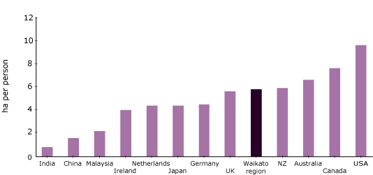
The graph below shows the ecological footprints per person for Waikato, New Zealand and other countries3. It can be noted that:
- the ecological footprint of an average Waikato resident (5.8 ha person) is slightly smaller than that of an average New Zealander (5.9 ha per person)
- the ecological footprint of an average Waikato (or New Zealand) resident is about 7 times greater than that of an average person living in India
- Waikato’s (and New Zealand’s) per person ecological footprint is also larger than that of Japan and many European Nations
- New Zealand’s ecological footprint is in the top 10 (which includes the United States, Canada and Australia) out of 150 nations surveyed in the 'Living Planet Report 20064.
Th data file spreadsheet contains the source data to this indicator's graph and any additional data. The data were collected between 2003-2004.

Methods - how we monitor
More information
When this indicator is updated
This indicator is due to be updated.
Indicator developments
This indicator is the second comprehensive and systematic quantification of the Waikato region ecological footprint. Significant improvements have been incorporated into the analysis including:
- greater resolution of the within economy transactions has been achieved through the use of a 48-industry breakdown of the economy compared with the earlier 23 industry breakdown
- the incorporation of land use data from Agriquality New Zealand's database
- the incorporation of extended reporting on other important resources and emissions such as delivered energy, energy related air emissions and solid waste production.
The indicator could be further improved by:
- developing productivity indices for each New Zealand region. This would substantially improve the goods-based components of the Ecological Footprint i.e. agricultural land.
- adding to the number of resources, pollutants and other emissions analysed in the 'extended footprint'.
Resources
McDonald, G and Patterson M. 2001: Ecological Footprint of the Waikato Region. Report for Environment Waikato, published by McDermott and Fairgray Limited, Auckland.
McDonald, G.W. and Smith, N.J. (2006). Waikato Ecological Footprint 2004. Report prepared for Environment Waikato by Market Economics Limited, Takapuna, Auckland, November 2006.
Footnotes
1. Based on McDonald and Patterson’s (2001) unadjusted Waikato Regional ecological footprint figure of 2.87 ha per person.
2 and 3. McDonald and Patterson’s figure adjusted using Loh’s methodology.
4. Hails, C (ed.) 2006. Living Planet Report
5. Copyright: Information obtained from Statistics New Zealand may be freely used, reproduced, or quoted unless otherwise specified. In all cases Statistics New Zealand must be acknowledged as the source.
6. Statistics New Zealand. 2004: Sub-national population estimates 2001-2026. Wellington. Statistics New Zealand.
7. Quotable New Zealand. 1998: Unpublished land area data disaggregated by 99 use codes for all regions in New Zealand. Wellington. Quotable New Zealand.
8. Ministry of Agriculture and Forestry. 2004: A National Exotic Forest Description as at 1 April 1998. Wellington. Ministry of Agriculture and Forestry.
9. Agriquality New Zealand. 2004. Regional Agricultural Land Use by Farm Type. Wellington. Agriquality New Zealand.
10. Works Consultancy Services. 1996: Transit New Zealand National Traffic Database. Contents and Operation of Database. Transit New Zealand Research Report No. 53. Wellington. Transit New Zealand.
11. Energy Efficiency Conservation Authority (EECA). 2004: Energy Use Database. Handbook. Wellington. EECA.
12. Hollinger, D.Y., Maclaren, J.P., Beets, P.N. and Turland, J. 1993:Carbon Sequestration by New Zealand Plantation Forests. New Zealand Journal of Forestry Science 23:2 194-208.

To ask for help or report a problem, contact us
Tell us how we can improve the information on this page. (optional)