Coastal erosion
Historic shoreline data is available for you to view on the Waikato Regional Hazards Portal.

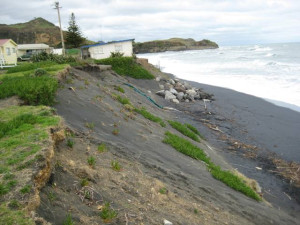
Mōkau coastal erosion
Coastal erosion is a natural process that is part of natural beach behaviour. Most shorelines vary between periods of sand erosion and accretion (building up).
Unfortunately, much of our coastal development in the Waikato region has occurred too close to the sea, resulting in coastal erosion risk.
What causes coastal erosion?
Short-term erosion
Short-term erosion can be caused by storms without causing a permanent change in the position of the shoreline. The area usually recovers; however, a full erosion and recovery cycle can take several decades. When viewed over a long period, such as a hundred years, the shoreline in the Waikato Region is simply shifting backwards and forwards. The largest shoreline changes are usually seen near estuary and river entrances.
Long-term erosion
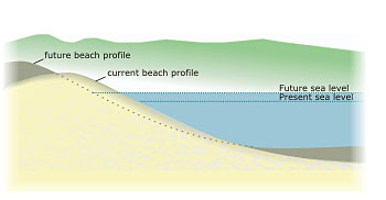
Long-term erosion occurs when there is a permanent change to the position of the shoreline, caused for example by a lack of sediment supply or by sea-level rise.

Future sea level rise, driven by climate change, may drive a long-term trend of coastal erosion. We need to manage this carefully so we can protect our coastline's future.
Coastal pressures
People’s activities can put pressure on our coasts by interfering with natural coastal processes. In many cases, this increases coastal hazard risk. Coastal processes can be affected by:
- damage or loss of sand dunes or dune vegetation
- shoreline structures to prevent erosion
- the removal of coastal plants and trees to preserve views
- removal of sands and aggregate from rivers or beaches.
Wide, well vegetated dunes provide a natural buffer that absorbs the effect of coastal erosion during storms, allowing the dune area to repair itself naturally. Natural dunes are therefore essential for protecting properties from coastal hazards. However, at many beaches, most of the dune sand reserves now lie buried under houses. Shoreline protection structures (such as seawalls) are then often added to protect threatened property. These structures degrade the natural and recreational values of beaches and often affect public access along the beach at high tide.
Main coastal erosion hazard areas
Current and historic areas of coastal erosion in the Waikato region include:
- the west coast communities of Port Waikato, Mōkau and Aotea Harbour
- the eastern Coromandel communities of Cooks Beach, Buffalo Beach and Whangapoua Beach
- the western Coromandel communities of Tararu and Te Puru.
In many cases, we are working with the relevant district council to manage this hazard.
Although our region’s coastal areas don’t yet appear to be eroding in the long-term, future sea level rise (and other projected climate change effects) will change this. Beaches on the eastern Coromandel Peninsula could erode more than 15-20 metres over the next century, greatly increasing the number of properties and houses at risk.
Shoreline change monitoring
We collect beach profile data and have cameras installed at multiple sites to provide information on shoreline change. Find out more about our work and the data we have available.


