Protected coastal areas
Why we monitor protected coastal areas
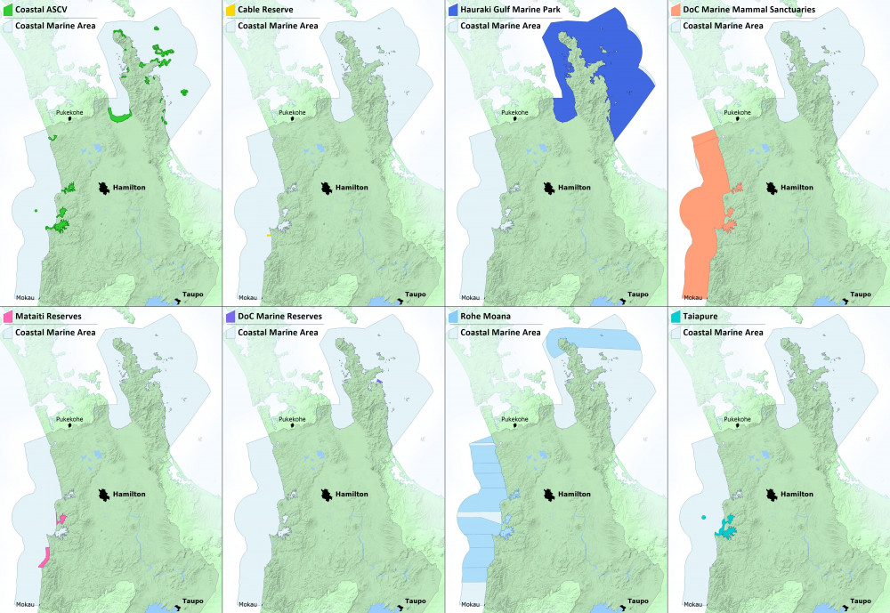
This indicator monitors the area of Waikato Regional Council's marine environment which is legally protected or subject to management controls. For the purpose of this indicator, the marine environment is defined as the area from Mean High Water Springs out to the 12 nautical mile territorial limit (i.e., the Coastal Marine Area, or CMA).
Monitoring the coastal marine area helps us to better manage current pressures and future economic growth. Ensuring a full range of habitats are protected will help to ensure that marine biodiversity is preserved.
The Waikato Regional Policy Statement 2016 sets out a policy of protection of significant areas, the objective being to preserve ecological integrity and indigenous biodiversity. The Waikato Regional Coastal Plan contains policies aiming to identify and protect significant vegetation and habitat and to ensure the protection of biodiversity.
What's happening?
The coastal marine area can be awarded varying degrees of protection:
Marine Reserves provide the highest level of protection of the marine environment. Currently, only one marine reserve exists in the Waikato region: Te Whanganui-A-Hei, near Hahei. It covers an area of nearly 800 hectares (ha).
Marine Parks represent another level of protection, in which certain activities may be restricted. The Hauraki Gulf Marine Park includes the Firth of Thames and the coastal marine area around the Coromandel Peninsula.
Marine mammal sanctuaries restrict particular activities, such as mining and seismic surveying, to protect marine mammals.
Areas of Significant Conservation Value (ASCVs) afford legal protection (as outlined in the Regional Coastal Plan) to many of the region’s important estuarine environments and spawning grounds.
Other forms of protection include areas designated as local fishing grounds under the Maori Fisheries Act 1989 and submarine cable and pipeline zones.
Methods - how we monitor
Results - data and trends
Download the data file
This Excel spreadsheet contains the source data for this indicator.
More information
When this indicator is updated
The coastal protection indicator will be updated every 5 years, the next one scheduled for 2025.
Updated 16 April 2020.
Related links
Marine Protected Areas: Tier 1 statistic 2019 - Department of Conservation: This report provides the current statistics relating to marine protected areas (MPAs) inshore of the outer (12 nautical mile) limit of New Zealand's Territorial Sea.
Marine Protected Areas: Classification, protection standard and implementation guidelines (2008) - Department of Conservation: These are the classification, protection standard and implementation guidelines for the Marine Protected Areas: policy and implementation plan.
Marine Protected Areas: Policy and Implementation Plan (2005) - Department of Conservation: This policy is a key means of protecting a full range of New Zealand’s marine habitats and ecosystems.
Area based restrictions in the New Zealand marine environment (2004) - Department of Conservation: Most of these restrictions cover commercial and recreational fishing and other marine harvesting such as shellfish or seaweed gathering. There are also restrictions on activities near underwater cables and pipelines and restrictions covering harmful materials in the marine environment.
National Aquatic Biodiversity Information System (NABIS) - Ministry for Primary Industries: This is a GIS website application that provides maps of marine biological and fisheries management data, including some protected areas.


To ask for help or report a problem, contact us
Tell us how we can improve the information on this page. (optional)