

“Completing the high-res, 3D mapping of our entire region back in June was an amazing milestone. But what’s even more exciting is what we can do with that information.”
- Waikato Regional Council Spatial Analysis and Modelling Team Leader Bryan Clements
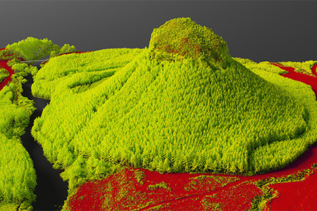
The verdant peaks and elegant contours of Mt Pirongia, mapped with great precision.
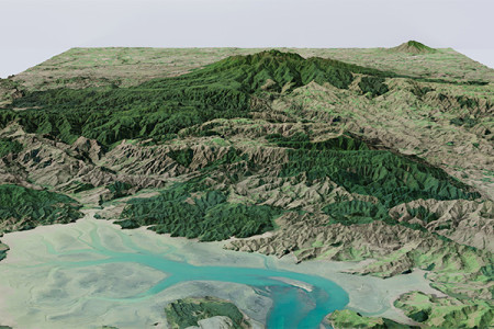
Using planes and lasers to map our entire region in 3D sounds awesome. And the high-definition results look stunning. But what is it good for?
As it turns out, the list of possible applications of LiDAR is long, and the benefits could be huge.
LiDAR stands for light detection and ranging. It involves firing lasers from a plane and measuring the time it takes for the light to bounce back. This enables the collection of detailed data to help determine the relative height of various landforms and man-made features.
The highly precise, 3D images produced can be used for all manner of purposes, including the creation of digital twins, which are models that can be used to simulate everything from traffic flows to lava flows.
Features of significance can be highlighted to help users visualise problems and solutions.
With such a risk-free emulation of real-world conditions, the potential for councils to deliver service improvements and cost efficiencies for ratepayers and residents is vast.
Not only that, using the technology to map, model and mitigate things like flood risk and determine the optimal placement of protective assets could help safeguard livelihoods and even save lives.
Waikato Regional Council’s Spatial Analysis and Modelling Team Leader Bryan Clements says his team has already identified dozens of potential applications and the list just keeps growing.
“Completing the high-res, 3D mapping of our entire region back in June was an amazing milestone. But what’s even more exciting is what we can do with that information.” says Bryan.
“Historically, the accuracy of the maps available to us – particularly at the sub-catchment level where the majority of the work we do work tends occur – has been limited.
“LiDAR now means we’re talking about accuracy to around the nearest 10 centimetres.
“With that level of detail, you can model things like floods of varying severity to see where the water would go, and make even better decisions about things like asset maintenance as a result.
“It can also help you understand where new investment may be needed to manage the risks associated with increasingly severe weather events caused by climate change.”
The publicly available Elevation Aotearoa LiDAR data is the culmination of a multi-agency project to develop a consistent 3D dataset across 10 regions, including the Waikato, Taranaki and Canterbury.
And Bryan says it’s not just councils that are seeing the potential.
“It’s still early days on the LiDAR-related ideas and projects we have in the pipeline, and identifying cost savings will, of course, play an important part in their development.
“But, to give one example of the sort of thing that’s possible here, the forestry management firm Manulife wanted to enable road access to one of their sites. The project was going to cost them over $300,000. Using LiDAR data enabled them to save vast sums on surveyors and boots-on-the-ground site assessments, bringing the total cost down to around $10,000.
“Our work with LiDAR will significantly improve our ability to model natural hazards and climate change, design better infrastructure, support better land use planning, urban and transport planning, improve environmental outcomes and drive significant efficiencies.”

To ask for help or report a problem, contact us
Tell us how we can improve the information on this page. (optional)