Shallow lakes of the Waikato region
The Waikato region’s shallow lakes are the largest remaining collection of their type in New Zealand. Many special native plants and animals live in and around them.
A careful land use balance is needed around these lakes, and Waikato Regional Council is working with landowners to ensure their protection.
What are shallow lakes?
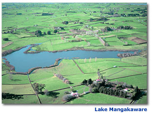 Shallow lakes in the Waikato region generally have an average depth of less than 3 metres. Their surface areas range from less than 1 hectare (0.01 km2) to over 3,000 hectares (30 km2).
The Waikato region's shallow lakes are divided into four main groups:
- Peat lakes.
- Riverine lakes.
- Taupo Volcanic Zone lakes.
- West Coast sand dune lakes.
Shallow lakes are often rich in plants and animals, and play an important role as wildlife refuges.
Plants found near the edges of lakes are used to having ‘wet feet’ and include kahikatea, flax, cabbage trees, manuka, and rushes and sedges. They provide food and cover for birds and other animals, such as insects and fish living in the lakes.
Waterfowl, such as grey duck and banded rail, rely on shallow lakes for food, shelter and breeding habitat.
Shallow lakes and their surrounding wetlands also play a role in storing extra water from the Waikato and Waipā rivers during floods. Without them, flood damage downstream to the lower areas of the Waikato would be more severe.
One of the smallest shallow lakes in our region is Lake Posa at Templeview, near Hamilton, with a surface area of 2.9 hectares (0.029 km2).
The biggest shallow lake is Lake Waikare at Rangiriri, with a surface area of 3,440 hectares (34.4 km2). One of the deepest and clearest lakes is Lake Rotomānuka, south of Ōhaupo, with a depth of 8 metres.
Stable lake conditions
Shallow lakes have two distinct stable states, generally depending on the amount of nutrients present in the water:
- Low nutrients - clear water, dominated by underwater (submerged) aquatic plants (macrophytes).
- High nutrients - murky (turbid) water, dominated by microscopic algae (phytoplankton).
Lakes with moderate nutrient levels are not stable in either state and can ‘switch’ from one state to the other, often suddenly. The factors causing a lake to change state are called 'pressures'. Pressures that cause a lake to change from clear to turbid water include:
- increased nutrient levels entering the lake, for example from changing land use in the lake’s catchment
- the introduction of plant or animal pests, which disrupt the lake’s ecosystem
- water abstraction, which lowers the lake’s water level.
When these switches are reversed a lake can change from turbid to clear water, for example, when a lake’s nutrient levels are reduced.
The diagram below shows how pressures can change a clear lake from its ‘pristine’ state to a modified turbid state and vice versa.

Stages of change
Lakes affected by increased nutrient levels generally go through five stages of change, during which the lake’s trophic status changes and water goes from clear to turbid.
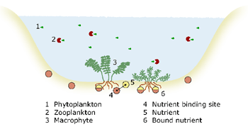
Stage 1 - Pristine condition (natural state)
- Clear water (except peat lakes, which have naturally ‘stained’ water).
- Lake floor dominated by aquatic plants (macrophytes).
- Few microscopic algae (phytoplankton).
- Bottom sediments are the main source of nutrients.
There is a balanced food web, supporting a wide variety of species, including:
- macrophytes – large aquatic plants that live underwater (submerged)
- phytoplankton – microscopic algae
- zooplankton - animal plankton which feed on the phytoplankton
- fish that feed on the zooplankton
- carnivorous fish that feed on the smaller fish.
Stage 2: Catchments are developed and land use changes
- Increased levels of nutrients enter the lake (onset of eutrophication).
- Sediments lock up nutrients that are not taken up by plants.
- Macrophytes respond to increased nutrient levels by growing more quickly and increasing in number.
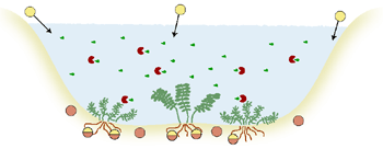
Stage 3: Increased plant growth – after a long period of nutrient enrichment
- Sediments can still lock up nutrients not taken up by plants.
- Macrophytes no longer increase in number, however phytoplankton (microscopic algae) continue to increase.
- Nutrient levels continue to increase.
- Zooplankton numbers start to decline due higher numbers of fish that feed on them.
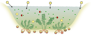
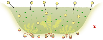
Stage 5: Collapse of large submerged aquatic plants (macrophytes)
- Macrophytes die off as light and oxygen levels drop.
- Phytoplankton are dominant and there are regular algal blooms.
- Nutrient levels in the water are very high.
- The variety of life in the lake is greatly reduced.
- Oxygen levels in the water decrease.
- Nutrients are released from the sediment into the water as oxygen levels drop.
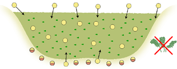
Land use effects on lowland lakes
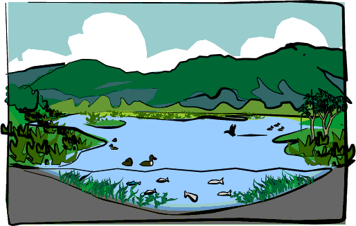
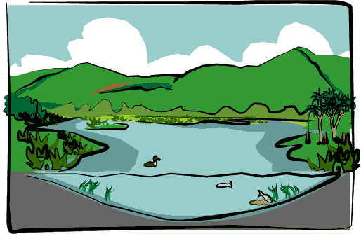
After development of the surrounding catchment the condition of the lake has changed markedly.
The forested hills have been cleared for pasture. Nutrient-rich runoff from fertiliser, animal wastes and sediment has washed in from surrounding farms. These nutrients have boosted the growth of water weeds and algae in the lake, which have competed with native plant species and reduced the clarity of the water.
The native aquatic plants have died off, and native bird and fish numbers have declined. Pest fish, such as koi carp and rudd, are now present.
Caring for our shallow lakes
Reducing the amount of nutrients entering a lake plays a key role in its protection. Waikato Regional Council works with local community groups and management agencies to care for our lakes and help restore them to their natural state.
Many of our lakes have had high nutrient levels for many years, with nutrients stored in the sediment and the water. Scientists are experimenting with ways turbid lakes can be switched back to a clear, pristine state:
Physical techniques, such as fountains, that increase the circulation of water and air within the lake to increase oxygen levels. This slows the release of nutrients from bottom sediments into the water.
Chemical techniques to bind nutrients into bigger and heavier compounds that sink to the bottom of the lake. This reduces the amount of nutrients in the water, making less available for phytoplankton.
Biological techniques that help to restore the natural balance of lake life. For example, the introduction of carnivorous fish, which feed on smaller fish, which feed on zooplankton. The resulting increase in zooplankton (animal plankton) helps to keep phytoplankton (plant plankton) levels low.
You can help
- Keep stock away from lake edges.
- Fence any lakes on your property.
- Plant lake edges with native plants.
- Form a Lakecare group in your area.


