Why we monitor peat lake water levels
The region’s 31 peat lakes are concentrated around the Waikato and Waipa Districts, and Hamilton City (though one is found in Otorohanga District) where their association with peat formations has had a marked effect on their physical, chemical and biological nature.
The Waikato peat lakes form the largest collection of peat lake habitat in New Zealand and are valuable conservation refuges for many unique plant and animal species. They represent some of the few remaining areas of wetland in the formally extensive Komakorau, Rukuhia and Moanatuatua peat bogs. The Waikato peat lakes are valued for their unique genetic diversity, cultural and spiritual importance, scientific interest, recreational opportunities and intrinsic value.
The development of peat bogs for agriculture has adversely affected water quality and quantity, as well as biodiversity and natural character of almost all peat lakes.
The Waikato peat lakes are particularly vulnerable to water level lowering. In the past, much of the wetland area in the region was drained to provide farmland for agricultural purposes. Drainage and cultivation of peat is essential to establish productive pastures and crops, but it results in irreversible shrinkage and oxidation of peat soils.
Continued deepening of drainage systems is often required to maintain the productive capacity of the peat soils. Where excessive shrinkage occurs adjacent to the sensitive peat lakes, lake water can ‘spill out’ onto surrounding farmland unless outlet drains are lowered. As a consequence, the lakes are now much shallower and occupy far less surface area than they did in the past. Shallower lakes are more exposed to environmental variables that can lower water clarity (for example, increased wind stir re-suspending bottom sediments).
The installation of water control structures in high risk peat lakes is a crucial step to ensure the sustainability of these ecosystems.
What's happening?
Before Europeans settled, most of the peat lakes in the Waikato region would have had no inlets or outlets. Instead, seasonal influences (for example, rainstorms or droughts) were responsible for variations in lake levels. Water probably entered the lakes from adjacent peat bogs and rainfall, and was lost mainly through evaporation.
The Waikato region’s peat lakes are vulnerable to the lowering of water levels. Changes in land use, particularly land clearance and drainage, have resulted in most peat lakes becoming very shallow. Uncontrolled drainage could even result in them disappearing completely.
Today, Waikato Regional Council is working with other Waipa Peat Lakes and Wetlands Accord signatories to protect the minimum water levels of peat lakes.
Members of the Waipa Peat Lakes and Wetlands Accord include:
- Waipa District Council
- Ngaa Iwi Toopu o Waipa
- Department of Conservation
- Auckland Waikato Fish and Game Council, and
- Waikato Regional Council.
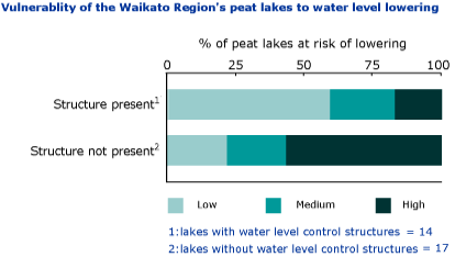
Structures are being installed in peat lakes where there is a high risk of their water level being lowered. These structures (culverts or weirs) help control the water leaving the peat lakes.
There are 31 peat lakes within the region of which 19 do not have water level control structures. All peat lakes, including those with control structures, have been assessed in terms of the risk of their water level dropping. This risk is determined as high, medium or low.
Methods - how we monitor
Results - data and trends
Download the data file
This Excel spreadsheet contains the source data to this indicator's graph and any additional data.
More information
When this indicator is updated
This indicator will be updated annually.


