

Managing acid sulfate soils
Disturbance and drainage of acid sulfate soils poses a risk to the environment and infrastructure unless it is appropriately managed.
What are acid sulfate soils?
Acid sulfate soils are naturally occurring soils, sediments and peats containing iron sulfides that are typically found in low lying areas and formed during historic sea level rise and inundation of land close to coastal areas. However, they can also be found well inland. They are identified in the following two forms:
- Actual acid sulfate soils (AASS) which have already undergone oxidation and are highly acidic. They will usually appear as a yellow/orange colour with red mottling (jarosite/iron oxide) and typically found closer to the surface of the soil profile.
- Potential acid sulfate soils (PASS) are unoxidised but have potential acidity on exposure to oxygen. They will usually appear as dark grey in colour but can also be dark brown, or medium to pale grey to white and are typically found lower down in the soil profile below AASS.
What’s the problem with acid sulfate soils?
When left undisturbed in a waterlogged state, potential acid sulfate soils do not typically cause problems but when soils are drained or excavated or the water table drops significantly during extended dry periods, they become oxygenated and produce AASS and acidic conditions which can cause:
- mobilisation of metals and nutrients from the soil profile which can be transported to groundwater and waterways which can result in drinking water contamination, fish kill events and other environmental effects; and
- harm to public and private infrastructure due to the corrosion of metal and subsurface concrete structures (such as reticulated water networks / pipelines, building foundations etc).
What to look for?
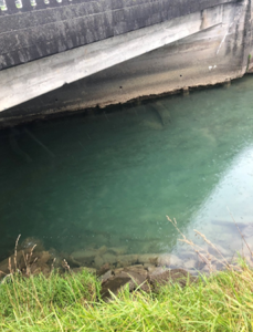
- Waterways & concrete infrastructure that are impacted by ASS can have orange coloured staining as a result of iron oxides leaching under acidic conditions.
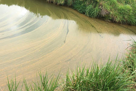
- Naturally occurring aluminium can be released in large amounts into water ways which can result in usually turbid waterways suddenly turning very clear or milky blue-green due to the natural flocculating properties of aluminium compounds.
- Signs of poor vegetation growth and scalded or bare low-lying areas.
- The presence of any sulphurous odours (rotten eggs smell).
An orange scum (iron oxide precipitate) can form within impacted waterways |
Rapid change in water clarity that is typically turbid is an indicator of impacts from acid sulfate soils |
Where are they found?
- Well recognised as a problem around the world including Australia and the UK with associated policy and regulation.
- Presence in the northern parts of NZ has been known about since the 1970’s.
- Only more widely investigated in NZ recently, typically in relation to large infrastructure projects, mainly in Northland, Auckland and the Waikato.

Regional mapping layer
A mapping layer of acid sulfate soil probability of occurrence for the Waikato region has been developed by GHD Ltd. The map provides a preliminary risk assessment of high, medium, low and negligible occurrence of acid sulfate soils within the Waikato region. Technical report TR2023/24 explains the methodology used to develop the mapping layer.
The searchable mapping layer is available for specific areas of the Waikato region on the biodiversity and environment, and flood protection and land drainage assets Waikato Maps.
Top tip: Ensure the the acid sulfate soil layer is selected and zoom in to a scale of at least 1:36000 for it to be visible.
Disclaimer
Earthworks and drainage activities within areas of medium to high risk of acid sulfate soil occurrence
Activities that have the potential to disturb acid sulfate soils, either directly by soil excavation, or indirectly by affecting the elevation of the water-table, need to be managed appropriately to avoid environmental harm.
The potential for soil disturbance or dewatering to cause significant adverse effects will depend on the scale of the activity and the depth of disturbance. For example, disturbance of shallow surface soils to a depth of no more than one metre is unlikely to pose a significant risk whereas disturbance below one metre is much more likely to intercept unoxidized acid sulfate soils and result in acidic conditions and mobilisation of metals. Likewise, a small-scale disturbance will pose much less risk compared to disturbance of a significant volume of soil. Close proximity to waterways and interception of groundwater will also increase the risk.
There are several Australian guidance documents that provide detailed advice on how to carry out investigations and to manage excavation and dewatering activities in areas where acid sulfate soils have been identified. For example:
Guidance materials for acid sulfate soils | Environment, land and water | Queensland Government
The National acid sulfate soils guidance: National acid sulfate soils sampling and idenitification methods manual also provides useful recommendations on “When do sites need to be investigated for acid sulfate soils?
Avoidance and or minimisation of disturbance in areas where acid sulfate soils are present is the recommended approach where possible. Adoption of alternative or specific construction methods should also be considered e.g., minimising disturbance by using piling to contain excavations.
The following management controls and procedures are commonly used:
- Reducing depth of excavations & excavating wider, shallower drainage channels;
- Minimising disturbance by using piling to contain excavations;
- Containment of excavated spoil for testing and treatment, usually on a purpose-built treatment pad;
- Containment and detention of stormwater runoff from the disturbance and treatment pad areas for testing and treatment (typically using lime neutralisation) prior to release;
- Neutralisation of excavated soil with calcium carbonate (CaCO3) such as ‘98% CaCO3 AgLime’;
- Containment of excavated or encountered water for testing and treatment (typically using lime neutralisation);
- Bunding and measures for protection of surrounding areas and waterways from the potential risk of acid contamination;
- Handling and disposal strategies for re-use or off-site disposal (i.e., neutralisation treatment is a typical requirement for acid sulfate soils before they can be received at an authorised disposal site); and
- Use of sulfate- and acid-resistant concrete formulations.
If you are planning an earthworks project in the Waikato region and the activity is located within a medium to high risk area of the acid sulfate soil map, we encourage you to fill out an online request for service form or contact Waikato Regional Council on 0800 800 401.

To ask for help or report a problem, contact us
Tell us how we can improve the information on this page. (optional)