Our Whitianga office will be closed to the public on Wednesday, 22 January. To report air or water pollution, unsafe water activities in or on a river, lake or harbour, or make a general enquiry or information request during this time, we can be contacted 24/7 on 0800 800 401.

Close alert

Firth of Thames - estuary monitoring results

REMP

Sediment-dwelling organisms

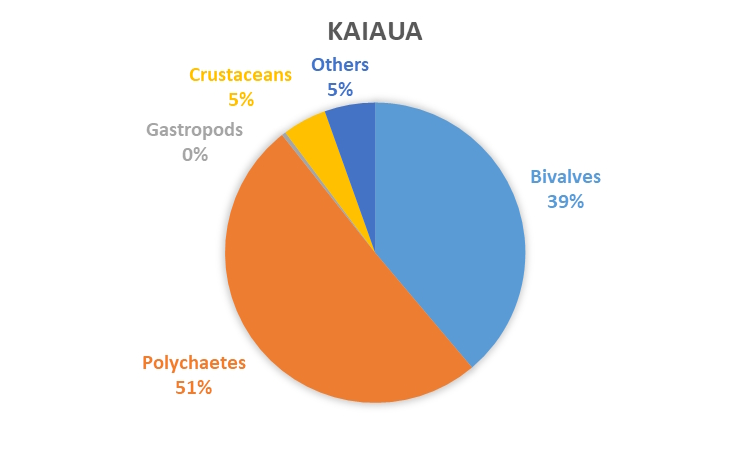
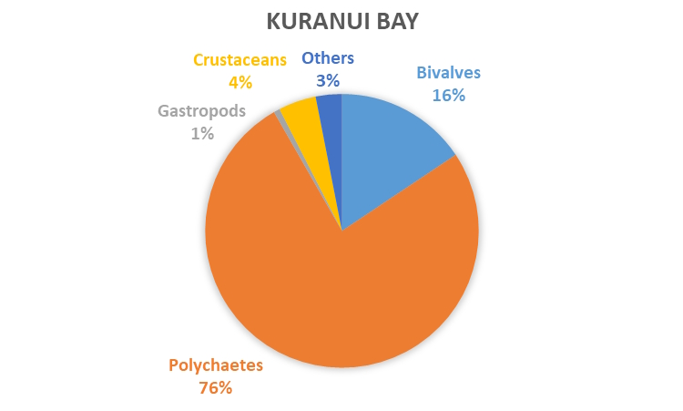
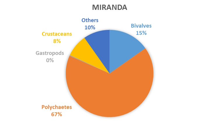
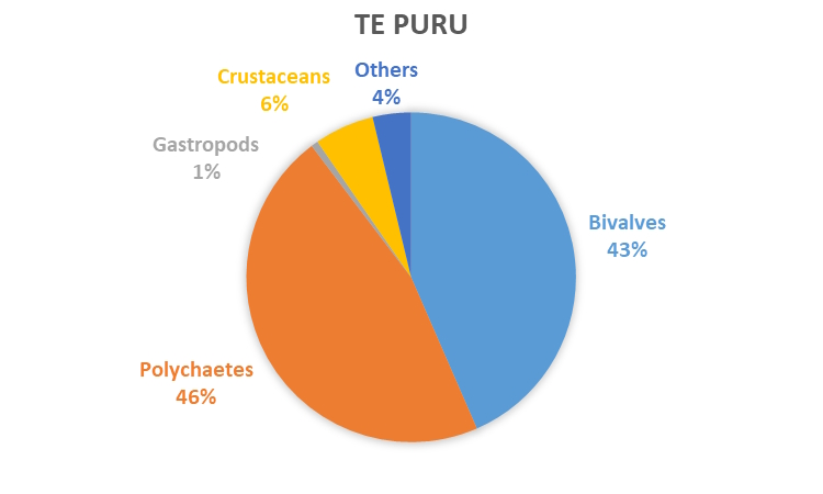
In the Firth of Thames the total number of individuals and composition of the sediment-dwelling organism community was relatively consistent at each site from 2012 to 2020. The only exceptions were low numbers at Kaiaua in 2017 and high numbers at Miranda in 2018.

Bivalves and polychaetes are the major components of the sediment-dwelling organism communities at all five Firth of Thames REMP monitoring sites. Crustaceans were relatively abundant at several monitoring locations but their abundance varies over time. Gastropods and other taxa are generally rare. Polychaetes are most abundant at the inner Firth locations Miranda (capitellids), Gun Club (Aonides trifida) and Kuranui Bay (capitellids). In contrast, bivalves are generally the dominant taxonomic group found at mid Firth locations Kaiaua (nut shells - Linucula hartvigiana) and Te Puru (pipi – Paphies australis and nutshells).

Of all monitoring locations, Gun Club, the innermost Firth of Thames monitoring location, has the greatest densities of sediment-dwelling organisms (on average 300 organisms per core). Other relatively abundant species include cockles (Austrovenus stutchburyi) at Kuranui Bay, pipi at Gun Club and capitellid polychaetes at Kaiaua.

A detailed analysis of all trends in our results as well as the relationships between sediment properties and sediment-dwelling communities are investigated in our latest trend report.
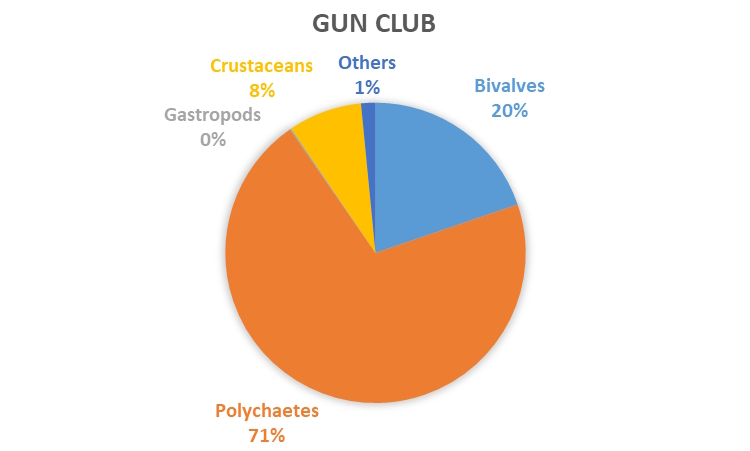
 

Firth of Thames sediment-dwelling organisms graph


Estuarine health indicator

An estuarine health index called the Traits Based Index (TBI) is used to track the health of our estuary sites over time, and to compare the health of different estuaries. It ranges between zero and one, with one being most healthy and zero being least healthy. The TBI is calculated based on the presence of different species or organisms at a site and uses biological traits (e.g. body size, mobility, feeding behaviour). The graph below shows all the sites in the Firth of Thames had similar TBI scores (with small changes between years), indicating that these sites are broadly similar to one another in terms of estuarine health. Most of the sites are moderately healthy (having a TBI score between 0.3 and 0.5).

More detailed information on the TBI can be found on the coastal biology indicator webpage.


Firth of Thames macrofauna indicator


Sediment properties

We measure sediment properties (including total organic carbon, total nitrogen, chlorophyll a, phaeophytin and grain size) at our monitoring sites and investigate if they are changing over time. Changes could indicate responses to mechanical disturbance, changes to water quality or the introduction of terrestrial sediment and contaminants. One important property we measure is grain size. If the intertidal flats are exposed to increasing sediment run-off from the catchment or other sources of fine sediment, the proportion of smaller grain sizes such as mud increases. This can create an unsuitable habitat for some sediment-dwelling animals. 

The graph below shows the average (± standard error) sediment mud content (%) at each monitoring site between 2012 and 2020. The standard error is a measure of how accurate the average is. The mud content is variable in the Firth of Thames, both between sites and from year to year. Overall Kaiaua has the highest mud content (average 16%), and Te Puru is the least muddy site (average 3%).

A full analysis of grain size and other sediment properties can be found in our latest trend report.


Firth of Thames sediment mud content