Constituencies
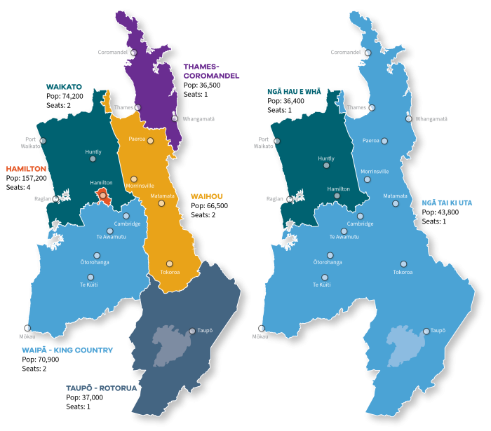
Constituency boundary maps

View our consitutency maps and boundaries. Enter a property address into our interactive mapping tool (see the link below) and find out what constituency the property is in.
Note: These maps were last updated in June 2025.
The maps use provisional Constituency 2025 datasets from Stats NZ. The final versions will be released later in 2025.
Enter your address, and view your property
To use the mapping tool
- click the drop-down arrow to expand the Constituencies list in the right hand menu
- deselect (un-tick) the constituency type option that doesn't apply (either General or Māori).
- click the drop-down arrow to expand the required constituency type, and view its boundary colours
- enter your address in the Search for address field (top left of screen).
- The map will then show your property in the correctly coloured location.
- You can zoom in and out of the map, using the + and - buttons, and move around using the arrow buttons or by click and dragging the map.
Representation review in 2024
Last year, Waikato Regional Council conducted a representation review, which it is required to do every six years to ensure compliance with the Local Electoral Act 2001 and the principles outlined in the Local Government Act 2002.
The last review was in 2018 for the 2019 and 2022 elections.
The review process included an initial proposal by the council; public consultation to gather feedback from the community; hearing of oral submissions; and a final council decision.
In this review, the council considered fair and effective representation, and communities of interest. Factors such as population data, demographic trends and projected population growth were all taken into account.
Council decided to continue to have 14 elected members, six general constituencies and two Māori constituencies.
Further details
See our Public notice below which contains full details of the final proposal.
Appeals
Any person who made a submission on the council’s initial proposal was able to lodge an appeal, relating to the matters raised in their submission, against the council’s decision.
The opportunity for submitters to appeal the final proposal closed on Friday, 6 September 2024.
No appeals were received. As such, the council decision to change the boundary of the Waihou and Thames-Coromandel constituencies becomes the basis of the next election in 2025.

